|
| at: |
Coleman River Scenic Area |
Data from David Muse
 show on map
 animate
Trail users:


Elevation Profile
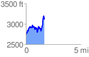
 1.697119 mi
 944.81 ft
 591.39 ft
 353.42 ft
 10.54 %
GPX Downloads: Track Route
![]()
|
| at: |
Coleman River Scenic Area |
show on map
animate
1.697119 mi
944.81 ft
591.39 ft
353.42 ft
10.54 %