| at: |
Coleman River Scenic Area |
Data from David Muse
 show on map
 animate
Trail users:


Elevation Profile
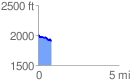
 0.844548 mi
 79.36 ft
 141.86 ft
 -62.50 ft
 3.18 %
GPX Downloads: Track Route
![]()
| at: |
Coleman River Scenic Area |
show on map
animate
0.844548 mi
79.36 ft
141.86 ft
-62.50 ft
3.18 %