| at: |
Coleman River Scenic Area |
Data from David Muse
 show on map
 animate
Trail users:


Elevation Profile
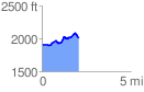
 2.065872 mi
 274.63 ft
 173.68 ft
 100.95 ft
 2.52 %
GPX Downloads: Track Route
![]()
| at: |
Coleman River Scenic Area |
show on map
animate
2.065872 mi
274.63 ft
173.68 ft
100.95 ft
2.52 %