|
| at: |
Gaddistown/Canada Creek |
Data from David Muse
 show on map
 animate
Trail users:


Elevation Profile
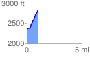
 1.000260 mi
 474.70 ft
 5.96 ft
 468.75 ft
 8.99 %
GPX Downloads: Track Route
![]()
|
| at: |
Gaddistown/Canada Creek |
show on map
animate
1.000260 mi
474.70 ft
5.96 ft
468.75 ft
8.99 %