|
| at: |
Coleman River Scenic Area Trans North Georgia |
Data from David Muse
 show on map
 animate
Trail users:


Elevation Profile
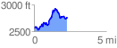
 2.278272 mi
 695.63 ft
 497.70 ft
 197.94 ft
 5.78 %
GPX Downloads: Track Route
![]()
|
| at: |
Coleman River Scenic Area Trans North Georgia |
show on map
animate
2.278272 mi
695.63 ft
497.70 ft
197.94 ft
5.78 %