| at: |
Coleman River Scenic Area |
Data from David Muse
 show on map
 animate
Trail users:


Elevation Profile
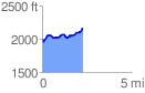
 2.249977 mi
 343.30 ft
 186.44 ft
 156.87 ft
 2.89 %
GPX Downloads: Track Route
![]()
| at: |
Coleman River Scenic Area |
show on map
animate
2.249977 mi
343.30 ft
186.44 ft
156.87 ft
2.89 %