| at: |
Chilhowee Recreation Area |
Data from Positive Flow
 show on map
 animate
Trail users:


Elevation Profile
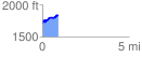
 0.900265 mi
 166.75 ft
 52.64 ft
 114.10 ft
 3.51 %
GPX Downloads: Track Route
![]()
| at: |
Chilhowee Recreation Area |
show on map
animate
0.900265 mi
166.75 ft
52.64 ft
114.10 ft
3.51 %