| at: |
Chilhowee Recreation Area |
Data from Positive Flow
 show on map
 animate
Trail users:


Elevation Profile
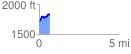
 0.652374 mi
 150.21 ft
 44.76 ft
 105.45 ft
 4.36 %
GPX Downloads: Track Route
![]()
| at: |
Chilhowee Recreation Area |
show on map
animate
0.652374 mi
150.21 ft
44.76 ft
105.45 ft
4.36 %