| at: |
Chilhowee Recreation Area |
Data from David Muse
 show on map
 animate
Trail users:


Elevation Profile
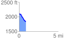
 0.853752 mi
 18.29 ft
 301.79 ft
 -283.50 ft
 6.69 %
GPX Downloads: Track Route
![]()
| at: |
Chilhowee Recreation Area |
show on map
animate
0.853752 mi
18.29 ft
301.79 ft
-283.50 ft
6.69 %