| at: |
LBJ National Grassland |
Data from USFS GIS
 show on map
 animate
Trail users:


Elevation Profile
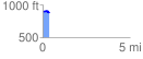
 0.366600 mi
 23.54 ft
 25.96 ft
 -2.42 ft
 1.34 %
GPX Downloads: Track Route
![]()
| at: |
LBJ National Grassland |
show on map
animate
0.366600 mi
23.54 ft
25.96 ft
-2.42 ft
1.34 %