| at: |
LBJ National Grassland |
Data from USFS GIS
 show on map
 animate
Trail users:


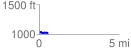
Elevation Profile
 0.566055 mi
 19.46 ft
 54.44 ft
 -34.98 ft
 1.82 %
GPX Downloads: Track Route
![]()
| at: |
LBJ National Grassland |
show on map
animate
0.566055 mi
19.46 ft
54.44 ft
-34.98 ft
1.82 %