|
| at: |
Warwoman WMA |
Data from USFS GIS
 show on map
 animate
Trail users:


Elevation Profile
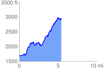
 5.538209 mi
 2101.89 ft
 747.70 ft
 1354.19 ft
 7.19 %
GPX Downloads: Track Route
![]()
|
| at: |
Warwoman WMA |
show on map
animate
5.538209 mi
2101.89 ft
747.70 ft
1354.19 ft
7.19 %