|
| at: |
LBJ National Grassland |
Data from USFS GIS
 show on map
 animate
Trail users:


Elevation Profile
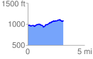
 3.155611 mi
 294.32 ft
 178.47 ft
 115.85 ft
 1.77 %
GPX Downloads: Track Route
![]()
|
| at: |
LBJ National Grassland |
show on map
animate
3.155611 mi
294.32 ft
178.47 ft
115.85 ft
1.77 %