|
| at: |
LBJ National Grassland |
Data from USFS GIS
 show on map
 animate
Trail users:


Elevation Profile
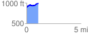
 1.077724 mi
 153.58 ft
 49.00 ft
 104.58 ft
 2.70 %
GPX Downloads: Track Route
![]()
|
| at: |
LBJ National Grassland |
show on map
animate
1.077724 mi
153.58 ft
49.00 ft
104.58 ft
2.70 %