|
| at: |
LBJ National Grassland |
Data from USFS GIS
 show on map
 animate
Trail users:


Elevation Profile
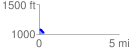
 0.322591 mi
 27.78 ft
 89.41 ft
 -61.63 ft
 5.25 %
GPX Downloads: Track Route
![]()
|
| at: |
LBJ National Grassland |
show on map
animate
0.322591 mi
27.78 ft
89.41 ft
-61.63 ft
5.25 %