| at: |
LBJ National Grassland |
Data from USFS GIS
 show on map
 animate
Trail users:


Elevation Profile
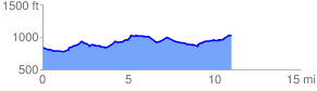
 11.473990 mi
 806.65 ft
 588.83 ft
 217.82 ft
 1.33 %
GPX Downloads: Track Route
![]()
| at: |
LBJ National Grassland |
show on map
animate
11.473990 mi
806.65 ft
588.83 ft
217.82 ft
1.33 %