| at: |
LBJ National Grassland |
Data from USFS GIS
 show on map
 animate
Trail users:


Elevation Profile
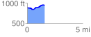
 1.554127 mi
 112.74 ft
 56.57 ft
 56.17 ft
 1.37 %
GPX Downloads: Track Route
![]()
| at: |
LBJ National Grassland |
show on map
animate
1.554127 mi
112.74 ft
56.57 ft
56.17 ft
1.37 %