| at: |
LBJ National Grassland |
Data from USFS GIS
 show on map
 animate
Trail users:


Elevation Profile
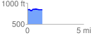
 1.329272 mi
 56.62 ft
 62.20 ft
 -5.57 ft
 0.89 %
GPX Downloads: Track Route
![]()
| at: |
LBJ National Grassland |
show on map
animate
1.329272 mi
56.62 ft
62.20 ft
-5.57 ft
0.89 %