| at: |
LBJ National Grassland |
Data from USFS GIS
 show on map
 animate
Trail users:


Elevation Profile
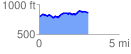
 3.300121 mi
 269.07 ft
 233.76 ft
 35.32 ft
 1.54 %
GPX Downloads: Track Route
![]()
| at: |
LBJ National Grassland |
show on map
animate
3.300121 mi
269.07 ft
233.76 ft
35.32 ft
1.54 %