| at: |
Caddo National Grassland Near Bonham |
Data from USFS GIS
 show on map
 animate
Trail users:


Elevation Profile
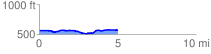
 5.102290 mi
 197.41 ft
 189.11 ft
 8.30 ft
 0.73 %
GPX Downloads: Track Route
![]()
| at: |
Caddo National Grassland Near Bonham |
show on map
animate
5.102290 mi
197.41 ft
189.11 ft
8.30 ft
0.73 %