| at: |
Caddo National Grassland Near Bonham |
Data from USFS GIS
 show on map
 animate
Trail users:


Elevation Profile
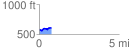
 0.771496 mi
 65.70 ft
 43.13 ft
 22.58 ft
 1.61 %
GPX Downloads: Track Route
![]()
| at: |
Caddo National Grassland Near Bonham |
show on map
animate
0.771496 mi
65.70 ft
43.13 ft
22.58 ft
1.61 %