|
| at: |
Caddo National Grassland Near Bonham |
Data from USFS GIS
 show on map
 animate
Trail users:


Elevation Profile
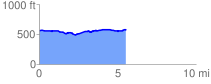
 5.535312 mi
 190.43 ft
 177.75 ft
 12.68 ft
 0.65 %
GPX Downloads: Track Route
![]()
|
| at: |
Caddo National Grassland Near Bonham |
show on map
animate
5.535312 mi
190.43 ft
177.75 ft
12.68 ft
0.65 %