| at: |
Caddo National Grassland Near Bonham |
Data from USFS GIS
 show on map
 animate
Trail users:


Elevation Profile
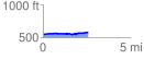
 2.555543 mi
 72.62 ft
 44.16 ft
 28.45 ft
 0.54 %
GPX Downloads: Track Route
![]()
| at: |
Caddo National Grassland Near Bonham |
show on map
animate
2.555543 mi
72.62 ft
44.16 ft
28.45 ft
0.54 %