|
| at: |
Angelina National Forest |
Data from USFS GIS
 show on map
 animate
Trail users:


Elevation Profile
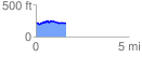
 1.647828 mi
 102.14 ft
 111.18 ft
 -9.04 ft
 1.28 %
GPX Downloads: Track Route
![]()
|
| at: |
Angelina National Forest |
show on map
animate
1.647828 mi
102.14 ft
111.18 ft
-9.04 ft
1.28 %