|
| at: |
Angelina National Forest |
Data from USFS GIS
 show on map
 animate
Trail users:


Elevation Profile
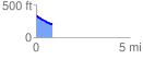
 0.865296 mi
 11.83 ft
 132.27 ft
 -120.44 ft
 2.90 %
GPX Downloads: Track Route
![]()
|
| at: |
Angelina National Forest |
show on map
animate
0.865296 mi
11.83 ft
132.27 ft
-120.44 ft
2.90 %