|
| at: |
Angelina National Forest |
Data from USFS GIS
 show on map
 animate
Trail users:


Elevation Profile
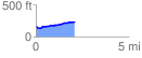
 2.084981 mi
 126.70 ft
 72.16 ft
 54.53 ft
 1.15 %
GPX Downloads: Track Route
![]()
|
| at: |
Angelina National Forest |
show on map
animate
2.084981 mi
126.70 ft
72.16 ft
54.53 ft
1.15 %