|
| at: |
Angelina National Forest |
Data from USFS GIS
 show on map
 animate
Trail users:


Elevation Profile
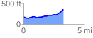
 3.250687 mi
 245.58 ft
 75.15 ft
 170.43 ft
 1.43 %
GPX Downloads: Track Route
![]()
|
| at: |
Angelina National Forest |
show on map
animate
3.250687 mi
245.58 ft
75.15 ft
170.43 ft
1.43 %