|
| at: |
Angelina National Forest |
Data from USFS GIS
 show on map
 animate
Trail users:


Elevation Profile
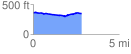
 2.886881 mi
 92.60 ft
 124.07 ft
 -31.46 ft
 0.81 %
GPX Downloads: Track Route
![]()
|
| at: |
Angelina National Forest |
show on map
animate
2.886881 mi
92.60 ft
124.07 ft
-31.46 ft
0.81 %