| at: |
Angelina National Forest |
Data from USFS GIS
 show on map
 animate
Trail users:


Elevation Profile
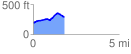
 1.799403 mi
 185.93 ft
 103.92 ft
 82.01 ft
 1.96 %
GPX Downloads: Track Route
![]()
| at: |
Angelina National Forest |
show on map
animate
1.799403 mi
185.93 ft
103.92 ft
82.01 ft
1.96 %