|
| at: |
Angelina National Forest |
Data from USFS GIS
 show on map
 animate
Trail users:


Elevation Profile
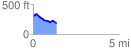
 1.360067 mi
 75.37 ft
 189.82 ft
 -114.44 ft
 2.64 %
GPX Downloads: Track Route
![]()
|
| at: |
Angelina National Forest |
show on map
animate
1.360067 mi
75.37 ft
189.82 ft
-114.44 ft
2.64 %