|
| at: |
Angelina National Forest |
Data from USFS GIS
 show on map
 animate
Trail users:


Elevation Profile
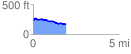
 1.909039 mi
 59.71 ft
 138.74 ft
 -79.03 ft
 1.38 %
GPX Downloads: Track Route
![]()
|
| at: |
Angelina National Forest |
show on map
animate
1.909039 mi
59.71 ft
138.74 ft
-79.03 ft
1.38 %