|
| at: |
Angelina National Forest |
Data from USFS GIS
 show on map
 animate
Trail users:


Elevation Profile
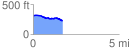
 1.734929 mi
 54.79 ft
 134.71 ft
 -79.92 ft
 1.47 %
GPX Downloads: Track Route
![]()
|
| at: |
Angelina National Forest |
show on map
animate
1.734929 mi
54.79 ft
134.71 ft
-79.92 ft
1.47 %