|
| at: |
Warwoman WMA Trans North Georgia |
Data from USFS GIS
 show on map
 animate
Trail users:


Elevation Profile
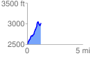
 1.237310 mi
 611.69 ft
 97.72 ft
 513.97 ft
 9.36 %
GPX Downloads: Track Route
![]()
|
| at: |
Warwoman WMA Trans North Georgia |
show on map
animate
1.237310 mi
611.69 ft
97.72 ft
513.97 ft
9.36 %