| at: |
Angelina National Forest |
Data from USFS GIS
 show on map
 animate
Trail users:


Elevation Profile
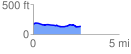
 2.781936 mi
 83.25 ft
 117.81 ft
 -34.57 ft
 0.80 %
GPX Downloads: Track Route
![]()
| at: |
Angelina National Forest |
show on map
animate
2.781936 mi
83.25 ft
117.81 ft
-34.57 ft
0.80 %