| at: |
Angelina National Forest |
Data from USFS GIS
 show on map
 animate
Trail users:


Elevation Profile
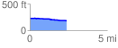
 2.399432 mi
 18.16 ft
 57.87 ft
 -39.71 ft
 0.46 %
GPX Downloads: Track Route
![]()
| at: |
Angelina National Forest |
show on map
animate
2.399432 mi
18.16 ft
57.87 ft
-39.71 ft
0.46 %