| at: |
Angelina National Forest |
Data from USFS GIS
 show on map
 animate
Trail users:


Elevation Profile
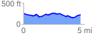
 4.718846 mi
 273.97 ft
 292.05 ft
 -18.07 ft
 1.17 %
GPX Downloads: Track Route
![]()
| at: |
Angelina National Forest |
show on map
animate
4.718846 mi
273.97 ft
292.05 ft
-18.07 ft
1.17 %