| at: |
Angelina National Forest |
Data from USFS GIS
 show on map
 animate
Trail users:


Elevation Profile
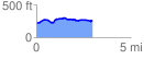
 2.958269 mi
 182.10 ft
 149.56 ft
 32.54 ft
 1.17 %
GPX Downloads: Track Route
![]()
| at: |
Angelina National Forest |
show on map
animate
2.958269 mi
182.10 ft
149.56 ft
32.54 ft
1.17 %