| at: |
Angelina National Forest |
Data from USFS GIS
 show on map
 animate
Trail users:


Elevation Profile
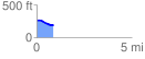
 0.874477 mi
 17.91 ft
 79.44 ft
 -61.53 ft
 1.72 %
GPX Downloads: Track Route
![]()
| at: |
Angelina National Forest |
show on map
animate
0.874477 mi
17.91 ft
79.44 ft
-61.53 ft
1.72 %