| at: |
Angelina National Forest |
Data from USFS GIS
 show on map
 animate
Trail users:


Elevation Profile
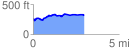
 2.971030 mi
 213.08 ft
 165.38 ft
 47.70 ft
 1.36 %
GPX Downloads: Track Route
![]()
| at: |
Angelina National Forest |
show on map
animate
2.971030 mi
213.08 ft
165.38 ft
47.70 ft
1.36 %