| at: |
Angelina National Forest |
Data from USFS GIS
 show on map
 animate
Trail users:


Elevation Profile
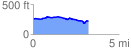
 3.229502 mi
 142.59 ft
 181.92 ft
 -39.34 ft
 1.07 %
GPX Downloads: Track Route
![]()
| at: |
Angelina National Forest |
show on map
animate
3.229502 mi
142.59 ft
181.92 ft
-39.34 ft
1.07 %