| at: |
Angelina National Forest |
Data from USFS GIS
 show on map
 animate
Trail users:


Elevation Profile
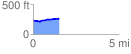
 1.509719 mi
 72.41 ft
 43.90 ft
 28.51 ft
 0.91 %
GPX Downloads: Track Route
![]()
| at: |
Angelina National Forest |
show on map
animate
1.509719 mi
72.41 ft
43.90 ft
28.51 ft
0.91 %