| at: |
Angelina National Forest |
Data from USFS GIS
 show on map
 animate
Trail users:


Elevation Profile
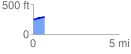
 0.690319 mi
 51.22 ft
 0.80 ft
 50.42 ft
 1.41 %
GPX Downloads: Track Route
![]()
| at: |
Angelina National Forest |
show on map
animate
0.690319 mi
51.22 ft
0.80 ft
50.42 ft
1.41 %