|
| at: |
Warwoman WMA |
Data from David Muse
 show on map
 animate
Trail users:


Elevation Profile
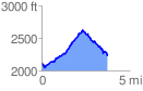
 3.746458 mi
 917.12 ft
 783.35 ft
 133.76 ft
 4.64 %
GPX Downloads: Track Route
![]()
|
| at: |
Warwoman WMA |
show on map
animate
3.746458 mi
917.12 ft
783.35 ft
133.76 ft
4.64 %