| at: |
Blue Ridge WMA |
Data from David Muse
 show on map
 animate
Trail users:

Elevation Profile
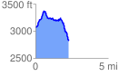
 2.295218 mi
 468.66 ft
 690.19 ft
 -221.53 ft
 5.70 %
GPX Downloads: Track Route
![]()
| at: |
Blue Ridge WMA |
show on map
animate
2.295218 mi
468.66 ft
690.19 ft
-221.53 ft
5.70 %