| at: |
Sabine National Forest |
Data from USFS GIS
 show on map
 animate
Trail users:


Elevation Profile
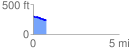
 0.769293 mi
 15.05 ft
 75.36 ft
 -60.30 ft
 1.86 %
GPX Downloads: Track Route
![]()
| at: |
Sabine National Forest |
show on map
animate
0.769293 mi
15.05 ft
75.36 ft
-60.30 ft
1.86 %