|
| at: |
Sabine National Forest |
Data from USFS GIS
 show on map
 animate
Trail users:


Elevation Profile
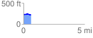
 0.627753 mi
 28.07 ft
 40.06 ft
 -12.00 ft
 1.21 %
GPX Downloads: Track Route
![]()
|
| at: |
Sabine National Forest |
show on map
animate
0.627753 mi
28.07 ft
40.06 ft
-12.00 ft
1.21 %