|
| at: |
Sabine National Forest |
Data from USFS GIS
 show on map
 animate
Trail users:


Elevation Profile
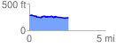
 2.571571 mi
 84.55 ft
 115.48 ft
 -30.94 ft
 0.85 %
GPX Downloads: Track Route
![]()
|
| at: |
Sabine National Forest |
show on map
animate
2.571571 mi
84.55 ft
115.48 ft
-30.94 ft
0.85 %