|
| at: |
Sabine National Forest |
Data from USFS GIS
 show on map
 animate
Trail users:


Elevation Profile
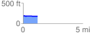
 1.204786 mi
 18.48 ft
 26.80 ft
 -8.32 ft
 0.42 %
GPX Downloads: Track Route
![]()
|
| at: |
Sabine National Forest |
show on map
animate
1.204786 mi
18.48 ft
26.80 ft
-8.32 ft
0.42 %