|
| at: |
Sabine National Forest |
Data from USFS GIS
 show on map
 animate
Trail users:


Elevation Profile
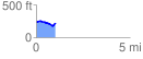
 1.049142 mi
 66.96 ft
 85.66 ft
 -18.70 ft
 1.55 %
GPX Downloads: Track Route
![]()
|
| at: |
Sabine National Forest |
show on map
animate
1.049142 mi
66.96 ft
85.66 ft
-18.70 ft
1.55 %