|
| at: |
Sabine National Forest |
Data from USFS GIS
 show on map
 animate
Trail users:


Elevation Profile
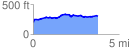
 3.825688 mi
 286.80 ft
 182.18 ft
 104.62 ft
 1.42 %
GPX Downloads: Track Route
![]()
|
| at: |
Sabine National Forest |
show on map
animate
3.825688 mi
286.80 ft
182.18 ft
104.62 ft
1.42 %